Location & Site or Block Plan
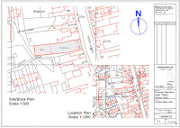
Most if not all planing applications require both a location plan and a block or site plan. The Location plan, as the name suggests, locates the site, it should be at a scale of 1:1250, or if its a really big site, then 1:2500, it should be based upon an up to date OS map, The Planning portal says it should be on an A4 sheet, I can't remember doing this ever, all mine are on A3 or larger. It should show sufficient road, road names, houses/buildings to locate the site, a north point and the site outlined in Red, I tend to use a poly line with a nice thick pen, and a little tone to shade the area. A blue line can also be used to show land owned by the client that is close by or adjacent to the site in question. The Site or Block Plan should be drawn at a larger scale I tend to use 1:500 although it can be 1:100 or 1:200, it should show the proposed development in relation to the site boundary again it should show north. Again it should show relevant buildings and road, and...